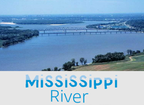
Mississippi River
Mississippi River
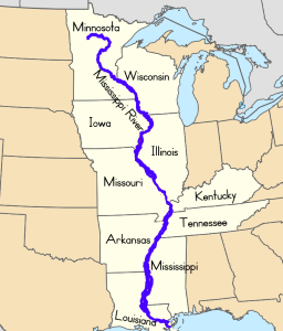
The Mississippi River flows through the middle of the United States. The Mississippi River is about 2,202 miles (3,543 km) long. It is the second-longest river in the United States, the Missouri river is the longest river by 200 miles (322 km).
Native Americans gave the Mississippi river its name. It is from a Native American word meaning "Father of Waters." Mississippi means "large river" to the Chippewa Indians and 'Great River' in the Algonquin language. The Mississippi River has many nicknames: Old Man River, Old Muddy, Father of Waters, and Mighty Mississippi.
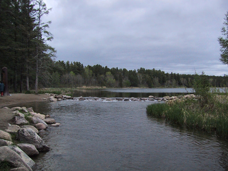
The source of the Mississippi River on
the edge of Lake Itasca in
Itasca State Park, Minnesota.
The Mississippi River begins at Lake Itasca in Minnesota and empties into the Gulf of Mexico. It begins at a small stream fed by Lake Itasca in Northern Minnesota. The river flows mainly southward through or along ten states into the Gulf of Mexico.
Mississippi River Video
Tributaries
Rivers are classified according to their stage of development as young, mature, or old. The Mississippi River is classified as a mature river. Mature rivers have many tributaries and carry a lot of water. They meander or snake across the flat plains. Its channels erode wider rather than deeper. The Mississippi Rivers is a menadering river that curves and bends as it flows toward the Gulf of Mexico.
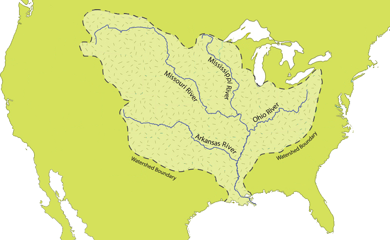
The Mississippi river is feed by many tributaries (a stream that flows to a larger stream or body of water), including the Missouri, Ohio, Illinois, Arkansas, and Atchafalaya rivers. As the tributaries flow into the Mississippi river they widen the river and add to its water volume.
A drainage basin, or watershed, is the land area from which rain and snow melt flows into a stream, lake, or a river. It takes many tiny drops of water all flowing together to develop a major river. Small drainage basins generally contribute to streams, while the water from larger drainage basins come together to form large rivers. In a drainage basin water flows from high to low areas and from upstream to downstream. Ultimately the river delivers the water back to the ocean.
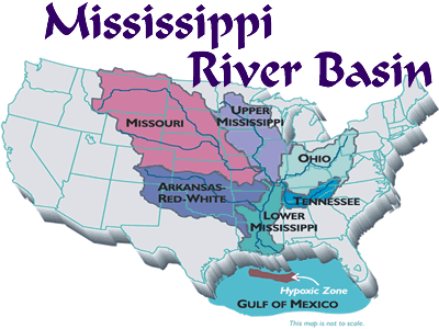
The Mississippi River has the third-largest drainage basin in the world. The Mississippi River drainage basin covers more than 1.8 million square miles (4.7 million square km). Only the Amazon River in South America and the Congo River in Africa drain larger areas.
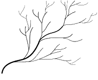
The drainage pattern of the Mississippi River is determined by the features of the land, on and below the surface. Drainage channels develop where surface runoff is enhanced and earth materials provide the least resistance to erosion. The Mississippi river has a dendritic drainage pattern. This pattern develops where an entire basin is made up of the same type of rock. A dendritic drainage pattern looks like the branches of a tree, a random branching with the tributaries joining the main river at all angles.
Transportation Route
The Mississippi River is a transportation route for cargo ships. In the 1800s, large commercial boats transported many goods up and down the river, including lumber and cotton. Today tons of cargo is carried on the Mississippi River each year.
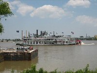
Steamboat Natchez, one of the last of the old paddle-wheelers on the lower Mississippi
Steamboats played a major role in the 19th Century development of the Mississippi River and its tributaries. Steamboats allowed large-scale transport of passengers and freight both up- and down-river. The first steamboat on the Lower Mississippi River was Fulton's New Orleans in 1811, coming from Pittsburgh, PA, down the Ohio River all the way to New Orleans.
Water Resource
The Mississippi River supplies drinking water for about 18 million people. It also supplies water to farms for crops and factories. About 50 cities relay on the Mississippi River for their daily water. The river provides freshwater for many species of plants and animals.
The Mississippi River forms the most important bird and waterfowl migration corridor on the continent.
The Mississippi River flows by and through many major cities such as; St. Paul, Minn., St. Louis, Mo., Memphis, Tenn., and New Orleans, La. The Mississippi River is one of the busiest rivers in the world as a commercial waterway and also a tourist destination.
Upper Mississippi River
People think of the river as being made up of two sections: the upper Mississippi and the lower Mississippi. The upper Mississippi River extends from the river's source in Minnesota to its junction with the Ohio River. Most of this section of the Mississippi River is clear and narrow. The river flows through hills, marshlands, and flat prairies.
In this region farmers grow corn and wheat on the land surrounding the river. The forests are pine, maple, oak, and hickory in this region of the Mississippi River. The upper Mississippi area has many animals: black bears, deer, moose, and beavers. The largest population of bald eagles in the lower 48 states of the USA are along the shores of the upper Mississippi.
Lower Mississippi River
The lower Mississippi River extends from the Mississippi River junction with the Ohio River to the mouth of the Mississippi River in the Gulf of Mexico. Most of this section of the Mississippi River is a brown muddy color and wide. In this region the main crops are rice, cotton, and sugarcane. The forests are oak, hickory, cypress, black willow, and cottonwood in this area of the Mississippi River. The Mississippi gopher frog is a small frog that lives only on the lower Mississippi River.

There are locks and dams on the upper Mississippi River. The Mississippi River, especially in the lower sections, can overflow its banks with disastrous results for people living nearby. Federal and state governments are vigilant in watch river flow patterns and trying to minimize flooding. The lower Mississippi River has levees, spillways, and dams for flood control.
There are locks and dams on the upper Mississippi River. The Mississippi River, especially in the lower sections, can overflow its banks with disastrous results for people living nearby. Federal and state governments are vigilant in watch river flow patterns and trying to minimize flooding. The lower Mississippi River has levees, spillways, and dams for flood control.
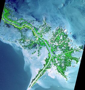
Mississippi River Delta from space.
Make A Mississippi River Flatboat Video
Young children make their own DIY flatboat while learning about the mighty Mississippi River.
Sites to See
The All-Star River Explorers
Discover the basics of rivers and how they are formed.
The Mighty Mississippi River Lesson (grades 3+)
A printable reading comprehension lesson.
Mark Twain Boyhood Home and Museum
Many of Mark Twain's famous stories are related to or take place near the Mississippi River.
Recommended Books

Where Is the Mississippi River?
by Dina Anastasio

Can You Canoe? And Other Adventure Songs
by The Okee Dokee Brothers

Houseboat Girl
by Lois Lenski
Can You Canoe? Video
Follow Us


Contact Us